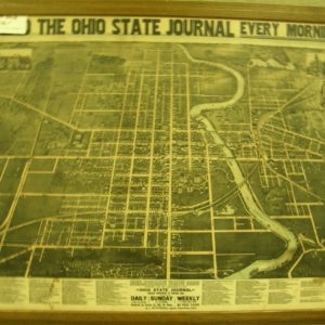
Delaware County Historical Society
  • HOME
  • ABOUT US
  • DONATE
    • DONATE
    • Sponsor Our Programs
  • SHOP
    • SHOP
    • Adopt-a-Memory
  • OUR NEWS
  • GET INVOLVED
  • CONTACT US
  • BARN AT STRATFORD
Select Page
Home / Map / 1849 Delaware County Map 19″ x 21-1/4″

1849 Delaware County Map 19″ x 21-1/4″

$5.00

SKU: M01 Category: Map
  • Description
  • Additional information

Description

1849 Delaware County Ohio Map

Size: 19″ x 21-1/4″

Created by James and George C. Eaton

Engraved by (Hugh) H. Anderson

1849 Map of Delaware County, also contains townships that are part of Marion and Morrow Counties. Attempts to show platted villages, roads, railroads, waterways, and land ownership.

Additional information

Weight 2 lbs

Related products

  • 1890 Delaware City Pictorial Map

    $99.00

Recent Posts

  • Meeker Museum Re-Opens with “The Journey to Delaware County”
  • July 2022 Local History Programs
  • Delaware Railroad Depot Project Awarded Tax Credit
  • Allured Bayard Nettleton
  • Irena Carpenter’s Journal – A Frontier Woman’s Perspective
© Copyright 2022 | Delaware County Historical Society, Delaware Ohio - Design & Powered by Imprescient